This tells us that the park is named for a portion of the Rio Grande and that 6 country's flags have flown over it.


At the visitor's center they posted this warning. Needless to say, we kept a close eye out for any threats!

We posted pics the other day of our hike thru some of the Chihuahuan Desert, and were surprised to learn that Big Bend is a part of that Desert too. There was a lot of cactus, but none that I could find that had flowers on them, so I took this pic at the visitor's center...it is called the Devil's Walking Stick! And next is a few pics of the Yucca plant that we saw before...but look at the flowers growing out of the top! FUN FACT: The Desert, on the hottest days of summer, can reach up to 180 degrees!


Needless to say, the park is really big, and so I guess it's not surprising that we weren't the 1st ones here.


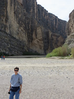
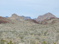
So much of this really looks prehistoric; miles and miles of rock formations of all different shapes and sizes. In this 2nd pic, from where Cathy is standing to the large wall of rock in the background is 14 miles away...as the crow flies! And once we drove 10 miles into the park from the north to get to the Visitor's Center, we took the Ross Maxwell Scenic Drive route from there to the southern-most section of the park that borders Mexico and is 30 miles long...breathtaking!


Here we are at the Santa Elena Canyon, where there is a literal split between the U.S. and Mexico. On the right side of the canyon is the U.S side, while the left belongs to Mexico. You will see here in a minute that the Rio Grande flows through the canyon.

Here we are walking in what amounts to a dry creek bed, what during the wet season would be the Terlingua Creek, which you have to cross to get to the canyon and Rio Grande. A close-up of the ground shows just how dry it is right now. And I don't know if the sign meant that it was 1.5 miles one way, but it took us 1 1/2 hours from start to round-trip finish.


To get up on the trail on the right side of the canyon, you 1st have to walk these switchbacks...the only somewhat strenuous part of the hike.


This tells us that the Rio Grande is actually 1885 miles long, with 1750 miles of that bordering 3 U.S states.

Considering that we are in drought conditions, and I think now is the dry season, the water you see below to the right of Cathy is all that separates us from Mexico at this point...sort of surprising we don't have even more people coming here every day! haha

The canyon is 8 miles long, but we could only go so far in before the trail ended (either 1.5 miles or half that?). And the walls reach up 1500 ft!


In the 2 pics directly above here, you can see that skinny part of the river that leads to the Mexican side of the canyon. Needless to say, I had to go down there to get the feeling of living dangerously! But I kept an eye out for the Federales! haha


Here are some pics we took as we went throughout the park, some of which I think are just breathtaking! You really have to click on them to appreciate them...and notice that some at the bottom of this grouping actually look like paintings...the area is called Desert Mountain and taken from an overlook there...crazy!


If your eyes are not yet blinded by the beauty, click on these stitch pics for a last blast!!!


Here were a family of Javelinas we saw by the side of the road...they ran, of course, so see them in the video scampering away. And lots of deer groups.


And finally, a picture out the window, driving home!!!

So that was our day...10 hours door-to-door and worth every second of it!!! We are actually looking into changing our plans...we have 3 more weeks before we go back to San Antonio...so we are looking at spending our last week on the road somewhere down closer to the park and cancelling what were going to do until another time. There is a lot more of it to see that we simply didn't have time for, so we are hoping to go back...time will tell what we can find. Hope you all enjoyed it!!!
Ok first, the sign of warning about the mountain lions would have made me stay in the car.....lol
ReplyDeleteSo I am grateful to see your pictures and videos because I will never see it in person.
The last picture from the car is beautiful
Hahaha I knew that would be your reaction, Ellen; that's why I posted it! I loved the sunset pic also, but some of the ones that I pointed out looking like paintings were pretty cool, too, I thought!
DeleteVery nice videos and pictures. You should have gone all the way into Mexico!
ReplyDeleteI wanted to Hallie, but was afraid I might be pushing my luck! haha
DeleteThis was one of the Blogs I looked at on the I-Pad. I LOVE the last picture. Such a beautiful catch. It would be beautiful enlarged and framed. Those Javellinas are SO ugly but the next pic of the deer make upo for it!!!!
ReplyDeleteI forgot to mention how scary and easy it appears that anyone can cross the border. Seems so simple???
ReplyDeleteNo kidding on how easy it is to "slip" across the border.
ReplyDeleteI am surprised that no one mentioned how some of he pics actually look like paintings...that really jumped out at me!